Da Nang Under Attack: The Landing in Old Prints and Maps
On the evening of 31 August 1858 a French-Spanish fleet reached the sea gate of Da Nang (Đà Nẵng, then Tourane). On 1 September Rigault de Genouilly sent an ultimatum, then opened fire. Nguyen dynasty troops held the forts at the Han river mouth. The last allied troops left on 22 March 1860.
In this guide
- Da Nang before 1858: a sheltered bay, fishing villages and a chain of forts
- Summer 1858: the fleet at the sea gate
- The first three days, through the court records
- Reading the 1859 maps of Tourane
- Nguyen Tri Phuong and the earth ramparts
- Empty villages, disease and hunger
- A stalemate into the spring
- What is left in Da Nang today
- About the images on this page
- Read next
- Common questions
Da Nang before 1858: a sheltered bay, fishing villages and a chain of forts
French archive documents call Da Nang Tourane, a corruption of Turão, the name used by Portuguese missionaries. The Tourane bay has an elliptical anchorage. Forest shelters ships from the monsoon, and a long small island keeps the water calm and apart from the open sea. That makes it very safe for sailors.
It was also the stretch of coast the French navy knew best.
Around the bay, villages lay scattered across the plain near rivers and creeks, and the people lived mostly by fishing. The People’s Army newspaper describes Da Nang as a sea gate of great strategic value, close to the capital Hue, ringed by mountains, and open to warships. The deep, wide harbour suited warships, and it lies only about 100 km from Hue.
How the Nguyen court guarded the sea gate
Nguyen dynasty court records, held by National Archives Center I in Hanoi, list the defences at the sea gate. They were Da Nang customs post (tan), Cu De post, Dien Hai citadel and An Hai citadel, the last two commanding the entrance to the Han river mouth. Beyond them stood a beacon tower, Dinh Hai fort, Phong Hai fort, 7 Tran Duong redoubts and the Hai Van defence line.
The Hai Van pass station stood on Hai Van mountain. It opened and closed the Hue-Da Nang road and gave a lookout down over Da Nang. Court records show the pass played an important part in relaying news from the Da Nang sea gate.
French ships had come before
French ships had visited before. In 1844 the warship Heroine came to demand that the Nguyen court release 5 missionaries. In 1847 two French warships came to provoke a clash and sank 5 bronze-hulled warships before leaving. On 25 September 1856, Charles de Montigny, angry at not being welcomed at Da Nang, ordered the ship Catinat to open fire, and failed.
Summer 1858: the fleet at the sea gate
The squadron’s flagship was the three-masted warship Nemesis, flying the flag of Vice Admiral Rigault de Genouilly. The force counted 1,500 French troops, backed by 1,450 Spanish and Tagal soldiers. Charles Rigault de Genouilly commanded, and the Spanish troops were led by Colonel Lanzarotte.
Some sources give about 3,000 troops. The archive figures are lower, since de Genouilly never commanded as many as 3,000.
On 28 August the whole squadron weighed anchor for Da Nang, and by 6 pm on 31 August it lay off the bay.
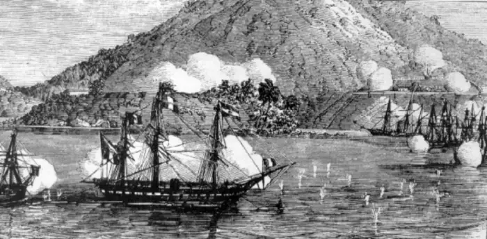
The engraving above is a French print of French warships at Da Nang, made in 1858-1859. The artist is unknown.
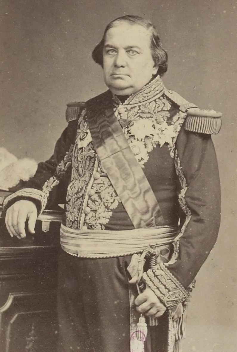
The portrait of Vice Admiral Rigault de Genouilly is a photograph by Pierre Louis Pierson. The French planned a lightning strike: take Da Nang, cross the Hai Van pass and hit Hue.
The first three days, through the court records
Court records (chau ban) are reports written to the emperor, so they show events from the Nguyen side, almost hour by hour. One report records the word of the commander at Hai Van pass. At the hour of Dau he saw 12 many-sailed ships and steamers enter Tra Son bay without firing.
Emperor Tu Duc ordered Tran Hoang to send more troops to strengthen the defence and report the situation at once.
On the morning of 1 September, de Genouilly sent an ultimatum giving the garrison commander two hours to hand over the citadel. The same day the allies opened fire on the Son Tra peninsula. A court record describes the scene. Ships fired salvo after salvo at forts 1, 2, 3 and 4 and at An Hai fort, and the forts fired back through thick smoke and dust.
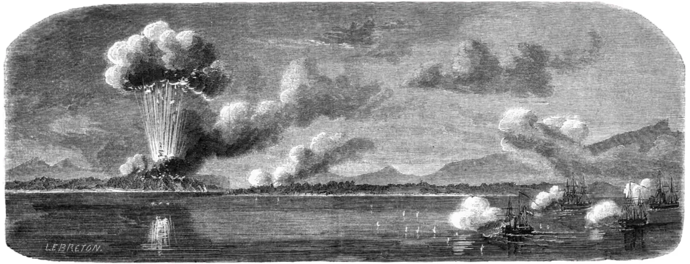
In this engraving by Louis Le Breton, the 1858 bombardment of Tourane blows up the east and west forts.
On 2 September ships closed in on Dien Hai and fired continuously at the fort, which returned fire from inside. The allies took the West fort and landed on the Son Tra peninsula. The People’s Army newspaper records Dien Hai falling at 10 am on 2 September 1858. By the end of 2 September, all the sea forts guarding the bay were in allied hands.
On the Nguyen side, Governor-General of Nam-Ngai Tran Hoang called up 2,070 off-duty soldiers of the province to stand ready, as the chronicle Dai Nam thuc luc records. The court sent Right Army Commander Le Dinh Ly with 2,000 palace guards from Hue to join the more than 2,000 soldiers under Tran Hoang.
The Vietnamese troops fought and fell back, setting up the Lieu Tri line in front of Hoa Vang district. General Le Dinh Ly was badly wounded and died in the fighting that followed.
Reading the 1859 maps of Tourane
The first drawing below is a map of Tourane found in the home of a Vietnamese military mandarin in 1859. It carries Sino-Vietnamese annotations, with a French legend at left.
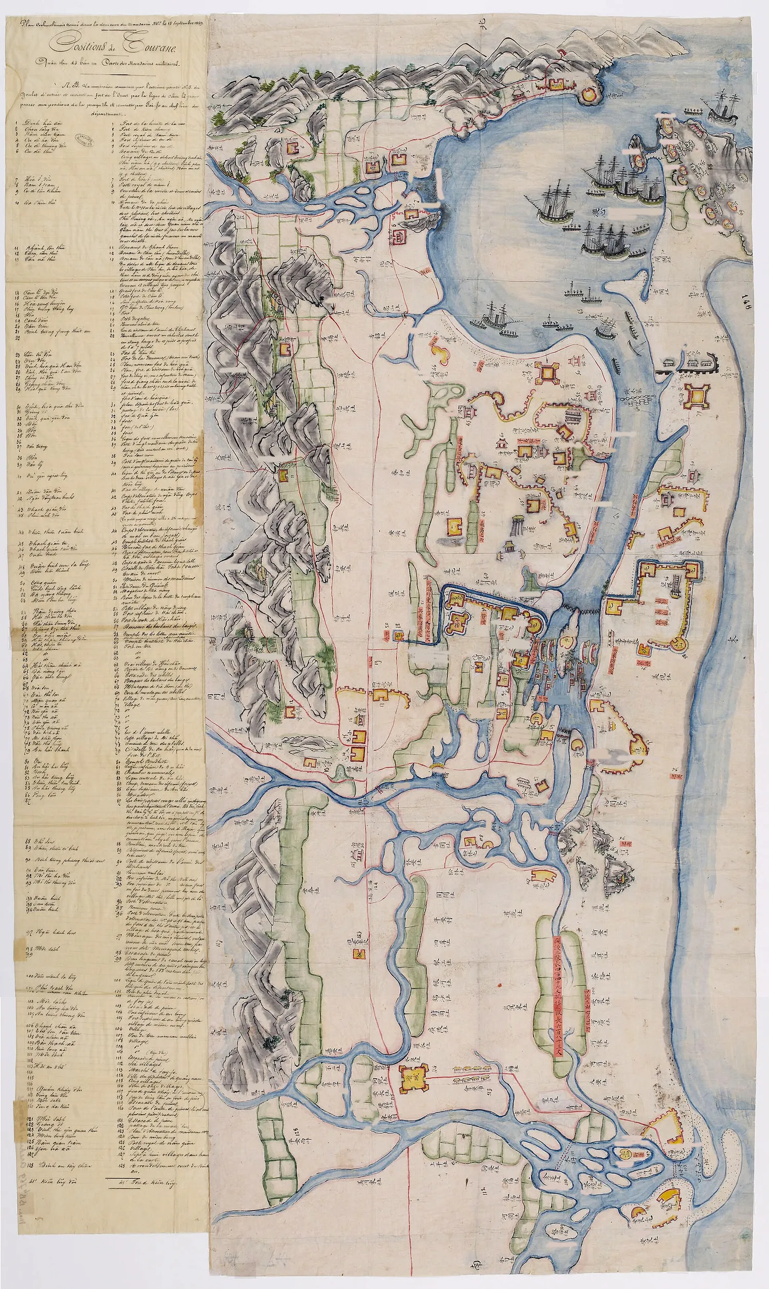
The second image is a detail of a drawing from the same period. The archive label says it was taken from a military mandarin on 15 September 1859. The bay is full of sailing ships, with forts and villages on shore.
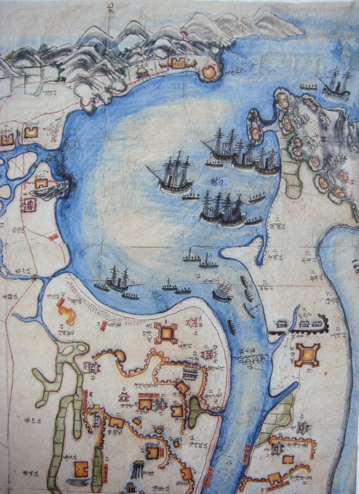
Sources on this battle name forts such as Hai Chau, Phuc Ninh and Thanh Gian on the long rampart that Nguyen Tri Phuong (Nguyễn Tri Phương) had built. The second line ran through Lien Tri, Nai Hien and Nghi Xuan. Some of these names reappear on the 1908 map at the end.
Nguyen Tri Phuong and the earth ramparts
Emperor Tu Duc sent Nguyen Tri Phuong, then Inspector-General of Nam Ky, to Quang Nam as supreme commander. On 10 October 1859 he reported to Hue that the court’s army in Quang Nam numbered more than 7,000 men. Desertion, dismissal, illness and reassignment had cut it by more than half, leaving 3,200 under arms.
With those forces he avoided a frontal fight against the enemy’s firepower. He used ambushes and a scorched-earth tactic, “empty gardens, empty houses”. He had a long rampart built from Hai Chau to Phuoc Ninh and Thanh Gian to hem the allies in at the shore. One court record tells of an ambush: when the foreigners came ashore, the hidden troops rose together and killed many of them.
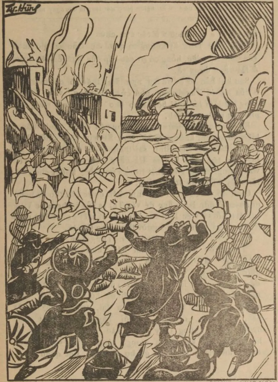
The picture above illustrates the battle at the Da Nang pass. It comes from Ngo Tat To’s book Nhung tran do mau hoi nguoi Phap sang ta den ngay nay published by Nhat Nam thu quan in Hanoi in 1935.
Weapons on the Nguyen side
The Nguyen court had prepared its defences well, as De Genouilly’s summary report to France admits. It had cannon on large-wheeled carriages suited to the terrain. It had flintlock muskets made in France or Belgium, and English gunpowder imported via Hong Kong and Singapore.
Empty villages, disease and hunger
What surprised the allies first was the empty village. They could find no fresh food because the villagers had left before the French attacked. They caught only a few buffalo, pigs and chickens left behind. The French commanders had not foreseen this because they trusted the missionaries’ reports that the French would be welcomed.
Disease then raged for months: dysentery, scurvy and fever. After five months of fighting the allies held only an empty mountain and a few empty coastal villages. In his report de Genouilly wrote that they were sliding into exhaustion at Da Nang. Of 800 infantry, at most 500 could still carry arms.
The allies pulled down houses in the citadel and many communal houses and pagodas to get materials for barracks, storehouses and hospitals. They built timber blockhouses; blockhouse No. 3 was shipped from Manila. In all, 4 blockhouses of this type stood along the Da Nang coast.
A stalemate into the spring
On 2 February 1859 de Genouilly took most of his troops south to open a new front at Gia Dinh, leaving about 1,000 men and 6 warships under Colonel Faucon. On 6 February Faucon led an attack on Hai Chau fort. Many French historians see the decision to withdraw south as a strategic dead end.
On 20 April 1859 de Genouilly returned to attack Dien Hai fort. On 8 May he split his force into three prongs. Nguyen Tri Phuong had to pull his troops back from the first line (Du Xuyen, Thac Gian, Hai Chau) to the second line (Lien Tri, Nai Hien and Nghi Xuan).
In the peace talks, de Genouilly put forward three demands: freedom to preach, freedom to trade and the opening of a concession. At exactly 4 am on 15 September 1859, three French and Spanish columns attacked the line together.
The Hai Van road and Chan Sang fort
The French government appointed Rear Admiral Page to replace de Genouilly, and on 18 November 1859 Page ordered an attack on the north of Da Nang. A court record notes that on that day French ships suddenly came up to Dinh Hai fort and Chan Sang post. Once the French held Chan Sang, the main road was cut.
Hai Van now became a matter of survival. In Nguyen times there were at least 3 routes over Hai Van. Woodcutters had their own paths, and it was they who showed the court’s officers and troops that route. The court ordered the small paths blocked with wood, stones and thorns, leaving only the main road.
The day they left
On 22 March 1860 the last allied troops left, after destroying all forts and works. The occupation had lasted 19 months. The archive documents presented by the State Records and Archives Department conclude that the allies failed to hold Da Nang. Paul Doumer’s memoir notes that the Annamites resisted fiercely, defended every inch of ground, and it took years to take it.
What is left in Da Nang today
On the Son Tra peninsula, right by the Tien Sa port gate, a memorial building still stands where allied soldiers who died in the battle of Da Nang were buried. The French built it in 1898, and locals call it the Spanish Cemetery (Nghia trang Y Pha Nho).
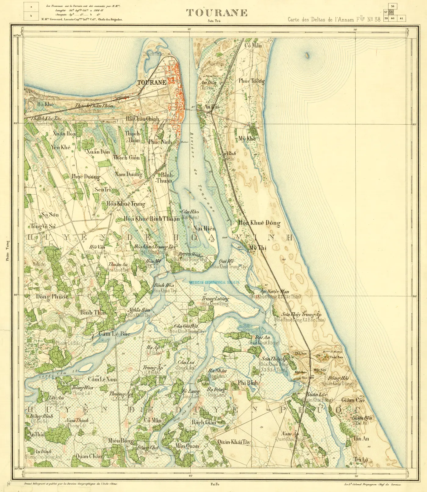
The 1908 map of Tourane covers the Han river mouth, the town and the villages around the bay. The names Nai Hien, Hai Chau, Phuc Ninh and An Hai are all still on it. The Indochina Geographic Service drew it.
About the images on this page
All images are in the public domain, taken from Wikimedia Commons. Each caption names the artist or source, the date and a link back to the original page.
Read next
Another son of Quang Nam: Phan Khoi. For the region’s food, see Mi Quang.
Photo credits
- French warships firing in Da Nang Bay. French print, 1858-1859, artist unknown: Wikimedia Commons, French print 1858-1859, unknown artist (opens in a new tab) (Public domain)
- Vice Admiral Charles Rigault de Genouilly, fleet commander. Photograph by Pierre Louis Pierson, 19th century: Wikimedia Commons, Pierre Louis Pierson (BnF Gallica), 19th century (opens in a new tab) (Public domain)
- The 1858 bombardment of Tourane that blew up the east and west forts. Engraving by Louis Le Breton: Wikimedia Commons, Louis Le Breton, 1858 (opens in a new tab) (Public domain)
- Map of Tourane around 1859, found in the home of a Vietnamese military mandarin. French legend on the left: Wikimedia Commons, map of Tourane c. 1859, unknown author (opens in a new tab) (Public domain)
- Detail of a Vietnamese plan of 1859: allied ships in the bay and the forts on shore: Wikimedia Commons, anonymous Vietnamese drawing, 1859 (BnF) (opens in a new tab) (Public domain)
- Illustration of the battle at the Da Nang pass in a book by Ngo Tat To, Hanoi, 1935: Wikimedia Commons, Ngô Tất Tố, Những trận đổ máu hồi người Pháp sang ta đến ngày nay (1935), public domain (opens in a new tab) (Public domain)
- Map of Tourane drawn by the Indochina Geographic Service in 1908: the village names Nai Hien, Hai Chau, Phuc Ninh and An Hai are all still on the map: Wikimedia Commons, Service géographique de l'Indochine, 1908, public domain (opens in a new tab) (Public domain)
Common questions
When did the attack on Da Nang begin?
On the evening of 31 August 1858 the allied force was off the sea gate of Da Nang. On the morning of 1 September Vice Admiral de Genouilly sent an ultimatum, then opened fire.
Why did the French choose Da Nang?
Da Nang is a deep, wide harbour that suited warships, and it lies only about 100 km from the capital Hue. The bay has forest sheltering ships from the monsoon and a long small island that breaks the sea, so it is very safe for sailors.
How large was the allied force?
The allied force counted 1,500 French troops, backed by 1,450 Spanish and Tagal soldiers.
When did the allies leave Da Nang?
On 2 February 1859 de Genouilly pulled most of his troops south to open a front at Gia Dinh. The rest withdrew on 22 March 1860, after destroying the forts and works.
What does Tourane mean?
Tourane is how French archive documents name Da Nang, a corruption of Turão, the name used by Portuguese missionaries.
Where is the Spanish cemetery in Da Nang?
On the Son Tra peninsula, near the gate of Tien Sa port, a memorial building still marks where allied soldiers who died in the battle of Da Nang were buried. The French built it in 1898; locals call it the Spanish Cemetery (Nghia trang Y Pha Nho).
Where do the images on this page come from?
From Wikimedia Commons, all in the public domain. Each caption gives the artist or source, the date and a link back to the original page.
Read next
- Phan Khoi: Bao An Writer Who Opened New PoetryVerified 18 October 2026
- Mi Quang: Origins, Phu Chiem Village, How It Is Made and Three ShopsVerified 18 October 2026
- Cham Sculpture Museum, Da Nang: The Tourane GardenVerified 18 October 2026
- Da Nang Under Attack: The Landing in Old Prints and MapsVerified 18 October 2026
General information checked against the sources listed above, not legal advice for your situation. Rules and office practice change; confirm with the relevant office or a licensed adviser before you act. See how guides are checked.
Spotted an error? Report it.