Hoai River, Hoi An: History, Lanterns and Boat Rides
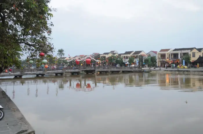
The Hoai River is the branch of the Thu Bon that flows through Hoi An old town, named after Hoai Pho village, where the Japanese quarter once stood. From the seventeenth century it was the riverfront of a busy international port. Boats cost VND 150,000-200,000 for a 15-20 minute ride, and a lantern costs VND 5,000-10,000.
In this guide
- Which river is the Hoai
- Before the town: Sa Huynh and the Cham port
- The name Hoai and the name Faifo
- The riverfront of the Japanese and Chinese quarters
- Assembly halls and the Japanese Bridge facing the river
- The river shifts and the port fades
- Taking a boat on the Hoai
- Floating lanterns
- The night market by the river
- What to eat near the river
- Common questions
Which river is the Hoai
The Hoai is the stretch of the Thu Bon (Thu Bồn) that flows through Hoi An old town. The old town sits on the Hoai, a branch of the “mother river” Thu Bon. The main Thu Bon flows between the Cam Nam and Cam Kim islets; the branch touching the old town is the one some books call the Hoi An river.
The mother river’s journey starts far away. The Thu Bon rises as small streams in the cinnamon and ginseng forests of Ngoc Linh mountain, which tops 2,500 m. Upstream it bears the rustic name Tranh river; only after joining the Vu Gia does it become the Thu Bon. Every March, villagers in Duy Xuyen hold the Ba Thu Bon festival.
The old town splits in two around the river. The main old quarter lies on the north bank, with Tran Phu and Nguyen Thai Hoc streets; across the bridge to the south is Cam Nam. Famous bridges over the river include Cau An Tuong and Cau Cam Nam.
Before the town: Sa Huynh and the Cham port
People lived around this river for a very long time. In Hoi An alone, more than 50 sites of the Sa Huynh (Sa Huỳnh) culture have been found, mostly on sand dunes along the old Thu Bon. Hoi An later grew on the inherited Cham seaport, and the Vietnamese began arriving from the fifteenth century.
The old waterway between Hoi An and the Han estuary survives today as the Co Co - De Vong river. Along that ancient route, many ship remains and anchors have been found buried underground.
Out at sea, the story continues on Cu Lao Cham.
The name Hoai and the name Faifo
The river took its name from a village. The old Japanese quarter stood in Hoai Pho (Hoài Phô), an ancient village, so the stretch of the Thu Bon through Hoi An came to be called the Hoai. Hoai Pho is recorded in the book O Chau Can Luc (1555). In the eighteenth century the village was renamed Hoa Pho, and later Son Pho.
Faifo, the name the French used for Hoi An, also comes from that village and river name. Alexandre de Rhodes’s Vietnamese-Portuguese-Latin dictionary, printed in Rome in 1651, defines Hoai pho as a village in Cochinchina where the Japanese lived, called Faifo.
The riverfront of the Japanese and Chinese quarters
The Nguyen lords let Japanese and Chinese merchants choose a site near the port of Hoi An to set up a quarter and live there permanently. From the seventeenth century Hoi An was a busy international port on this river. The Japanese quarter lay downstream, the Chinese quarter upstream.
The Japanese quarter formed around 1617 and flourished in the early seventeenth century. The first recognised mayor, in 1618, was Furamoto Yashiro. A stele carved in 1640 on Marble Mountains names the Japanese settlement nine times. In thirty years, 75 Japanese red-seal ships called at Hoi An, against 37 at Dong Kinh.
In 1651 a Dutch captain recorded about 60 Japanese houses along the riverbank, built of stone as protection against fire.
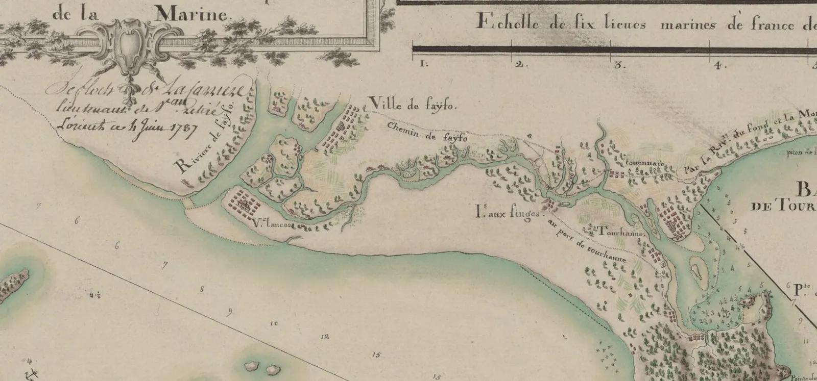
Le Floch de la Carrière’s nautical chart of 1787 draws both Fayfo (Hoi An) and the Bay of Tourane (Da Nang). Along the riverbank you see clusters of houses and the words “Ville de Fayfo” and “Rivière de Fayfo”. The author had visited Vietnam in 1755-1756, and this map is his second version of the region.
In 1695 the monk Thich Dai San (Thích Đại Sán) reached Hoi An and wrote about it in Hai Ngoai Ky Su. He described a street 3-4 li (dặm) long running straight along the riverbank, called Dai Duong Nhai. In the same year Bowyear described a port with a single big street on the riverbank and two rows of 100 houses, all Chinese.
Thanh Ha pottery and other craft-village goods travelled down the river, through the port of Hoi An and out to the world from the seventeenth century.
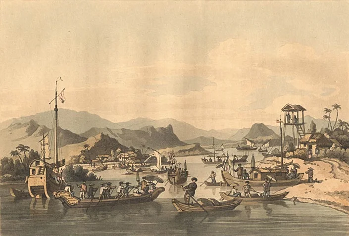
In the colour engraving from John Barrow’s travel book you see a very different Faifo: sailing boats, small passenger boats, a wooden tower on the bank. The plate is titled “Faifo”, printed in A Voyage to Cochinchina, London, 1806.
Assembly halls and the Japanese Bridge facing the river
The old town has five assembly halls for its five main Chinese communities: Fujian, Chinese (Ngu Bang), Chaozhou, Qiongfu and Cantonese. All stand on Tran Phu street and face the river.
The Japanese Bridge is about 18 m long and crosses a small channel that flows out to the Thu Bon. The 1630 map Thien Nam Tu Chi Lo Do already records the name “Hoi An Kieu” and draws a covered bridge. It is the “house above, bridge below” type.
Over the door of the small pagoda attached to the bridge hangs the tablet “Lai Vien Kieu”, granted by lord Nguyen Phuc Chu in 1719.
The river shifts and the port fades
After its heyday Hoi An lost its place as the leading trading port, partly from geographic change and partly from Nguyen policy that favoured the port of Da Nang.
In the nineteenth century the Thu Bon and Cho Cui rivers changed course, and deep channels silted up into new land. The silting of Cua Dai was one factor in the port’s decline. By 1847 only the Da Nang estuary still saw many ships.
The silt that choked the waterways also made new land for the town. Nguyen Thai Hoc and Bach Dang streets formed later, both on silted-up land. Nguyen Thai Hoc appeared in 1840. Bach Dang dates from 1878 and, lying right by the river, was once called the Riverbank Road.
On 9 October 1888, King Thanh Thai issued a decree founding the town of Faifo (Hoi An) as the provincial seat of Quang Nam. On 9 October 1905 the railway opened. In 1999 UNESCO recognised Hoi An old town as a World Cultural Heritage Site. The full story is in the history of Hoi An and Hoi An Ancient Town.
In the storm season, Nguyen Thai Hoc street and the area around it often flood, and residents use boats to shop and reach restaurants.
Taking a boat on the Hoai
Rowing visitors around is the main trade of many riverside residents. The boats use no motor engines.
Boat hire is posted at the quays at about VND 150,000-200,000 for a 15-20 minute ride. A small boat usually carries 4 to 5 guests. Ask the price at the quay and count your group before stepping aboard. Wear a life jacket.
The best time is 18:00 to 20:00, when the old town lights up. For fewer people and clearer photos, go around sunset, about 17:30.
Floating lanterns
The lantern festival has Buddhist roots and has been held regularly in the old town since 1998. To see the best night, arrive on the 14th of each lunar month. That night all electric lights in the old town go off, thousands of lanterns are lit, and boats fill the Hoai with floating lanterns. Lanterns are floated on the river on both the 14th and 15th.
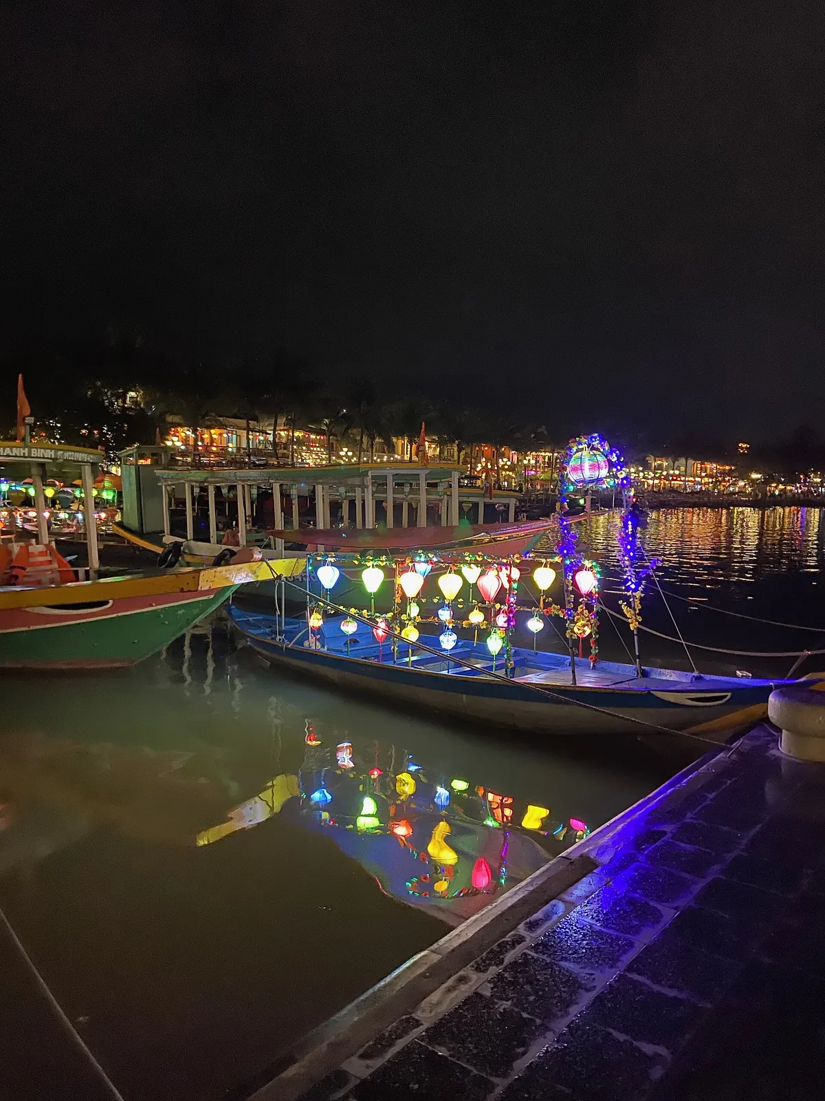
The lanterns are handmade coloured paper with a candle inside, at about VND 5,000-10,000 each. Float yours at the quays along either bank, or hire a boat to take you further out.
The night market by the river
The night market has two areas: Nguyen Hoang street for shopping and lanterns, and Cong Nu Ngoc Hoa for local food. It has no separate entry ticket and usually runs from about 17:00 to 23:00.
What to eat near the river
While in Hoi An, try Cao Lau, Mi Quang and Banh Beo. The usual dipping partner is Hoi An chilli sauce. If you are planning a day trip to sea, see Cu Lao Cham.
Photo credits
- The Hoai River and a bridge looking toward Hoi An old town: Wikimedia Commons — ChieuTimViet (opens in a new tab) (CC BY 3.0)
- The mouth of the Fayfo (Hoi An) river on Le Floch de la Carrière's 1787 nautical chart (held by the BnF, Gallica): Gallica (BnF) via Wikimedia Commons — René-Julien Le Floch de la Carrière (opens in a new tab) (Public domain)
- Faifo in John Barrow's travel book A Voyage to Cochinchina (London, 1806): Wikimedia Commons — John Barrow (opens in a new tab) (Public domain)
- Boats hung with lanterns beside the river in Hoi An at night: Wikimedia Commons — Kuroczynski (opens in a new tab) (CC BY-SA 4.0)
Common questions
Why is it called the Hoai River?
The old Japanese quarter stood in Hoai Pho (Hoài Phô) village, so the stretch of the Thu Bon through Hoi An is called the Hoai River. Alexandre de Rhodes's dictionary, printed in 1651, defines Hoai pho as a village where the Japanese lived, called Faifo.
Is the Hoai a separate river?
No. The Hoai is a branch of the Thu Bon, the "mother river" of Quang Nam. The main Thu Bon flows between the Cam Nam and Cam Kim islets.
How much is a boat ride on the Hoai River, and how many people fit?
Boat hire is posted at the quays at about VND 150,000-200,000 for a 15-20 minute ride. A small boat usually carries 4 to 5 guests.
What time is best for a Hoai River boat ride?
From 18:00 to 20:00, when the old town lights up. For fewer people, go around sunset, about 17:30.
When are lanterns released on the Hoai River, and how much do they cost?
The best night is the 14th of each lunar month, when all electric lights in the old town go off. Lanterns are floated on the river on both the 14th and 15th. A lantern costs about VND 5,000-10,000.
What time does the Hoi An night market open?
The night market has no separate entry ticket and usually runs from about 17:00 to 23:00. It has two areas: Nguyen Hoang street for shopping and lanterns, and Cong Nu Ngoc Hoa for local food.
When did UNESCO recognise Hoi An old town?
In 1999, as a World Cultural Heritage Site.
Read next
- Cu Lao Cham: History, Monuments, Boats and Calm SeasonVerified 18 October 2026
- Hoi An History: The Faifo Trading Port and Old TownVerified 18 October 2026
- Hoi An Old Town: Heritage, Assembly Halls, TicketsVerified 18 October 2026
- Cao Lau Hoi An: History, Noodle Makers and Three PlacesVerified 18 October 2026
General information checked against the sources listed above, not legal advice for your situation. Rules and office practice change; confirm with the relevant office or a licensed adviser before you act. See how guides are checked.
Spotted an error? Report it.