Hoi An History: The Faifo Trading Port and Old Town
Hoi An became a major trading port from the late 16th century, when the Nguyen lords let Japanese and Chinese merchants set up their own quarters. Trade here goes back to the second century BC. The port declined in the 19th century as the estuary silted up and Da Nang rose. UNESCO inscribed the old town on 4 December 1999.
In this guide
- Before it was called Hoi An
- Hoi An and Faifo: the story of the name
- Late 16th century: the Nguyen lords open the port
- The Japanese quarter
- The Chinese quarter and other merchants
- The Japanese Covered Bridge: the bridge between two quarters
- The trading quarter razed in 1775
- The 19th century: the Dai estuary silts up and Da Nang takes over
- Faifo under the French
- Forgotten, then seen again
- Where to see it
- Common questions
Before it was called Hoi An
The oldest trace of settlement at Hoi An is the Sa Huynh culture, which formed from about the third century BC into the early centuries AD. More than 50 sites of this culture have been found within Hoi An city alone. Han-dynasty Chinese coins found here show foreign trade from the start of the Common Era. Archaeological evidence also shows trade in the area from the second century BC.
After Sa Huynh, from the 2nd to the 15th century, the central coast lay under the kingdom of Champa. Under the Cham dynasties, in the 7th-10th centuries, this was an economic centre where Asian, Persian and Arab merchants came to trade. A ninth-century Arab merchant’s record already mentions the area. For the Cham in Quang Nam, see My Son sanctuary.
In 1471 the last Cham capital, at Bau Gia in Binh Dinh, was taken by the Le dynasty. Hoi An grew on the seaport the Cham left behind, and Vietnamese began arriving from the 15th century.
Hoi An and Faifo: the story of the name
The name Hoi An came later than people think.
In 1553 Dien Ban district had 66 communes, among them Hoai Pho, Cam Pho and Lai Nghi, but the name Hoi An is not yet recorded. Under the Le, a map by the court official Do Ba records the names Hoi An pho, Hoi An dam and Hoi An kieu for the first time. It is printed in Thien Nam tu chi lo do.
Under Lord Nguyen Phuc Lan, the Minh Huong village was founded beside the already existing Hoi An village.
Westerners called the place Faifo. Alexandre de Rhodes’s Vietnamese-Portuguese-Latin dictionary, printed in Rome in 1651, defines Hoai Pho as a village in Cochinchina where the Japanese lived and called it Faifo. The name Faifo comes from the village name Hoai Pho and the Hoai River. Later, on the official maps of the Indochinese government, the French all used the name Faifo for Hoi An.
Late 16th century: the Nguyen lords open the port
Historians hold that the Hoi An trading port began to take shape in the late 16th century, on the Thuan Quang lands of the Nguyen lords. Hoi An came into being around the second half of the 16th century.
From 1570, Nguyen Hoang kept his hold on Quang Nam as governor and widened trade with foreign countries. Hoi An became one of the busiest international ports in Southeast Asia of its day.
Outside events helped the port rise fast. In 1567 the Ming dynasty lifted its ban on sea travel. The Nguyen lords let many foreign residents, above all Chinese and Japanese, stay, set up streets and shops, and live by their own customs. So Hoi An came to have two self-governing quarters, one Japanese and one Chinese.
At its peak, ships of many nations called every year and a fair was held for 4 to 6 months running. In the first half of the 17th century Hoi An was the biggest trading centre of Dang Trong. It then drew not only merchants but missionaries and explorers. From the 15th to the 19th century this was a major trading post of Southeast Asia.
The Japanese quarter
Japanese red-seal ships began sailing abroad in 1604 under the Tokugawa shogunate. Of the red-seal ships that came to Vietnam, 86 out of 130 called at Hoi An. Japanese merchants brought copper, copper coins, iron and household goods to sell, then bought sugar, silk and aloeswood. European merchants of the time saw Hoi An as the Japanese people’s seaport.
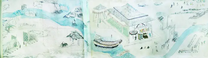
Around 1617 the Japanese quarter in Hoi An took shape and flourished in the early 17th century. It lay to the east, downstream on the river, and the Chinese quarter to the west, upstream. Chaya Shinroku’s scroll Giao Chi quoc mau dich do hai do shows the Japanese quarter with two- and three-storey timber buildings.
In 1651 the Dutch captain Delft Haven recorded that Hoi An then had about 60 Japanese houses along the river, built of stone against fire and standing wall to wall. The Japanese residence appears nine times on a stele at Ngu Hanh Son. Archaeologists have also found a great many objects tied to the Japanese.
Then the Japanese quarter faded. The Tokugawa shogunate closed the country and the Nguyen lords persecuted Japanese Catholics, so the quarter dimmed and the Chinese took over its trade.
It lasted to the end of the 17th century, and the Japanese who remained married Chinese and Vietnamese and gradually dissolved. Later, Vietnamese and Chinese rebuilt the town over the ruins in their own architecture, and the traces of the Japanese quarter were erased. What remains are the graves of Japanese and Chinese and the bridge that bears the name Japanese Bridge.
The Chinese quarter and other merchants
The Chinese knew Hoi An earlier than the Japanese. After the fall of the Ming, many Chinese migrated to central Vietnam and founded Minh Huong communities. The riverside street was called Dai Duong, stretching 3 or 4 miles. Most of its residents were Fujianese.
Seventeenth-century Hoi An also had a Dutch trading post. In 1695 the English envoy Thomas Bowyear of the East India Company came to negotiate with the Nguyen lord about building a settlement at Hoi An. The talks failed.
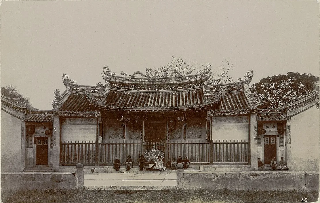
The clearest trace of the Chinese is the assembly halls. The photo above shows the Teochew Assembly Hall, taken between about 1891 and 1898. It is in an album by the photographer Gustave Trumelet-Faber, kept at the National Library of France, which names the place “Fei-Foo”. The same album has a photo of the heads of the Chinese congregations of Faifo from about the same time.
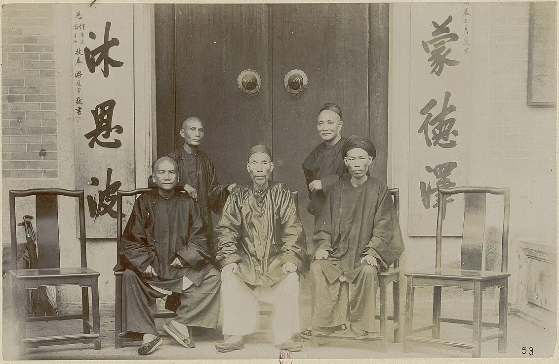
The five halls that survive today, and the story of each, are in Hoi An ancient town.
The Japanese Covered Bridge: the bridge between two quarters
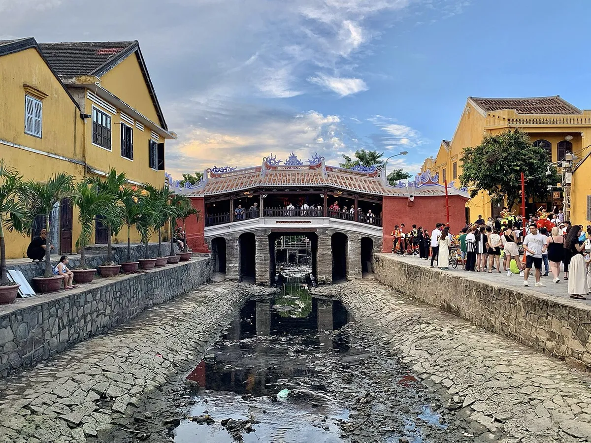
The Japanese Covered Bridge (Chùa Cầu) linked the Japanese quarter to the Chinese quarter. A Vietnam National Authority of Tourism document puts the Japanese building the bridge at about 1593. It was built from the late 16th to the early 17th century as the Japanese Bridge, for overseas Chinese and Japanese to cross and trade.
In 1630 the map Thien Nam tu chi lo do already drew a covered bridge at Hoi An. The monk Thich Dai San mentioned the bridge in his Hai ngoai ky su in 1695.
In 1719 Lord Nguyen Phuc Chu visited Hoi An, saw merchant boats crowding the Hoai River, and named the bridge Lai Vien Kieu, meaning bridge for visitors from afar. Its present shape came from repairs in the 18th and 19th centuries.
The bridge is about 18 metres long and crosses a small channel that flows into the Thu Bon River. It is built in the style of “a house above, a bridge below”. Small wooden platforms on both sides of the deck were once used to display goods for sale.
The Chinese built a temple on the bridge to worship Bac De, which is why people call it the pagoda bridge. A very small temple to Huyen Thien Dai De, tied to the bridge, was built about half a century after the bridge.
Each end of the bridge has two animal statues, a monkey on one side and a dog on the other. One explanation is that work began in a Monkey year and finished in a Dog year.
Folk tales say the Japanese built the bridge to hold down a sea monster whose turning shook the ground. Tradition says the Japanese built it, and it is now the symbol of Hoi An’s World Heritage.
The trading quarter razed in 1775
In 1775 Lord Trinh seized Quang Nam, and the port of Hoi An fell into war and chaos. Trinh troops razed the houses of the trading quarter and left only the religious buildings.
In 1778 an Englishman, Charles Chapman, passed through and recorded his grief at the ruin: “Alas, those buildings now live only in memory”. About 5 years later the port slowly revived, but trade was never the same.
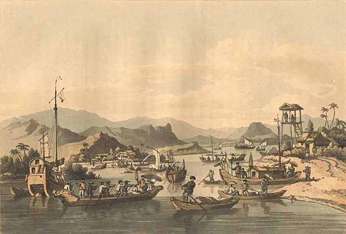
The engraving below shows the Faifo river in John Barrow’s account of his voyage to Cochinchina. The book tells of the voyage of 1792 and 1793 and was printed in London in 1806.
The 19th century: the Dai estuary silts up and Da Nang takes over
In the 19th century the Dai estuary kept narrowing and the Co Co River silted up, so large ships could no longer reach the port of Hoi An. With no lagoon deep and wide enough for ships to anchor, Hoi An’s economic importance dwindled.
The port declined partly through geographical change and partly because the Nguyen court favoured Da Nang port. The silting of the Dai estuary was one factor in that decline.
From the late 19th century the sailing-ship port gave way to the steamship port of Da Nang. In 1888, when Da Nang became a French concession, many Chinese went there to set up transport and trading businesses. For the Da Nang port, see the Da Nang history page.
Hoi An did not die outright. In the 5th year of Minh Mang’s reign, the king passed through Hoi An. He found it no longer as busy as before, yet still more prosperous than other Vietnamese towns. Most of the houses and assembly halls that remain today took their shape in this period.
Faifo under the French
Under the French, Tran Phu Street was named Rue du Pont Japonais, the street of the Japanese bridge. The area east of the old town was once the French quarter. On Phan Boi Chau Street, the western side is lined with European-style facades, mostly one storey. A photograph of Faifo taken from a Breguet 14 aeroplane in 1925-1930 survives; you can see it in Hoi An ancient town.
Forgotten, then seen again
When Quang Nam-Da Nang province was founded in 1976, Da Nang became the provincial capital and Hoi An fell into a period of neglect. From the 1980s, scholars from Vietnam, Japan and the West began to take notice of Hoi An. In 1993, Japan and Vietnam jointly began a programme to safeguard and conserve Hoi An.
On 4 December 1999, UNESCO inscribed Hoi An on the World Cultural Heritage list. The old town kept its traditional urban fabric and old-house architecture of the 15th to 19th centuries unbroken. UNESCO gave two reasons: Hoi An is an outstanding expression of cultures blending in an international trading port, and an outstanding example of a traditional Asian port town perfectly preserved.
By the count of December 2000, Hoi An had 1,360 monuments. They included 1,068 old houses, 11 old wells, 38 clan chapels, 19 pagodas, 43 shrines to spirits, 23 communal halls, 44 special old tombs and 1 bridge. A town like Hoi An is unique in Vietnam and rare in the world.
Where to see it
For visiting, ticket prices, opening hours and the distance from Da Nang, see Hoi An ancient town. For a dish that carries traces of the trading port, see cao lau; the noodle dish of all Quang Nam is in mi Quang.
Photo credits
- Chaya Shinroku's 17th-century scroll of the voyage to Giao Chi: Wikimedia Commons — Chaya Shinroku, Giao Chi quoc mau dich do hai do (17th century), public domain (opens in a new tab) (Public domain)
- The Trieu Chau Assembly Hall at "Fei-Foo", in an old photograph: Wikimedia Commons — Gustave Trumelet-Faber album, BnF Gallica (1891-1898), public domain (opens in a new tab) (Public domain)
- Heads of the Chinese congregations of "Fei-Foo" in an old photograph: Wikimedia Commons — Gustave Trumelet-Faber album, BnF Gallica (1891-1898), public domain (opens in a new tab) (Public domain)
- The Japanese Covered Bridge after renovation: Wikimedia Commons — Chainwit. (opens in a new tab) (CC BY 4.0)
- The river at Faifo (Hoi An) in John Barrow's account of a voyage to Cochinchina: Wikimedia Commons — John Barrow, A voyage to Cochinchina (1806), public domain (opens in a new tab) (Public domain)
Common questions
How old is Hoi An?
Archaeological evidence shows trade here from the second century BC. Under the Cham kingdoms (7th-10th centuries) it was an economic centre where Asian, Persian and Arab merchants came to trade. The Nguyen lords' trading port took shape from the late 16th century.
What does Faifo mean?
Faifo is the Western name for Hoi An, derived from the village name Hoai Pho and the Hoai River. Alexandre de Rhodes's dictionary, printed in Rome in 1651, defines Hoai Pho as a village in Cochinchina where the Japanese lived and called it Faifo.
Who built the Japanese Covered Bridge in Hoi An, and when?
It was built from the late 16th to the early 17th century as the Japanese Bridge, for Chinese and Japanese to cross and trade. In 1719 Lord Nguyen Phuc Chu named it Lai Vien Kieu.
When was the Japanese quarter of Hoi An founded?
Around 1617, the Japanese quarter took shape and flourished in the early 17th century. Japanese red-seal ships began sailing abroad in 1604.
Why did the Japanese leave Hoi An?
The Tokugawa shogunate closed the country, and the Nguyen lords persecuted Japanese Catholics, so the Japanese quarter faded and the Chinese took over its trade.
Why did Hoi An decline?
Partly because of geographical change, and partly because the Nguyen court favoured Da Nang port. The silting of the Dai estuary was one factor.
Was Hoi An destroyed?
In 1775 Lord Trinh seized Quang Nam, and the port fell into war and chaos. Trinh troops razed the houses of the trading quarter and left only the religious buildings.
When did UNESCO inscribe Hoi An?
On 4 December 1999, in Marrakech, Morocco.
Read next
- My Son Sanctuary: History, Towers, Tickets and TransportVerified 18 October 2026
- Hoi An Old Town: Heritage, Assembly Halls, TicketsVerified 18 October 2026
- Da Nang Under Attack: The Landing in Old Prints and MapsVerified 18 October 2026
- Cao Lau Hoi An: History, Noodle Makers and Three PlacesVerified 18 October 2026
General information checked against the sources listed above, not legal advice for your situation. Rules and office practice change; confirm with the relevant office or a licensed adviser before you act. See how guides are checked.
Spotted an error? Report it.